
BESNi
|
|
|
BESNi
|
Besni: Besni is
roughly 25 miles
from Adıyaman and has an area of roughly 600 square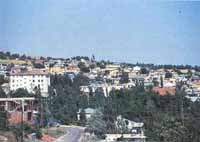 miles. Based on the
1990 census the district has a population of 88,531 with 26,076 living in the
central city of Besni. Besni has been called by different names throughout its
history. During the Assyrian period it was called Bathesna (pretty), during the Emevi period Hasen,
also meaning pretty in Arabic. The name Besni is driven from about 1350
when the town was called Bisni, a word that means “exceptional place”
in Arabic.
miles. Based on the
1990 census the district has a population of 88,531 with 26,076 living in the
central city of Besni. Besni has been called by different names throughout its
history. During the Assyrian period it was called Bathesna (pretty), during the Emevi period Hasen,
also meaning pretty in Arabic. The name Besni is driven from about 1350
when the town was called Bisni, a word that means “exceptional place”
in Arabic.
Besni
is one of the oldest settlements in southeastern Anatolia. The earliest settlers
of the area were Hittites. The area was subsequently under various kingdoms
including Babylonian, Urartu, Kummuhian, Assyrian, Kommagenean, Roman and
Sassanian. In 7th century Besni adopted Islam and
was ruled by
Islamic kingdoms, including Abbasid Caliphate, Seljuk and Ottoman Turks. After
the establishment
of the Turkish Republic, Besni became a subdivision of
Gaziantep province. In 1954 when Adiyaman itself became a province, Besni
became a part of Adiyaman.
The
most important economic activity of the region is the cultivation of vineyards
and pistachio nuts. Besni grapes are known nationwide. Tourism is also an
important activity as Besni hosts several important fortresses. The biggest of
these, called Bozmekan Kalesi by the locals, dates to around 6th
century and is famous for its several wonderfully preserved towers. The city is
also home to many old mosques as well as to Çermik spa reputed for its
therapeutic powers for ailments like arthritis and skin diseases.

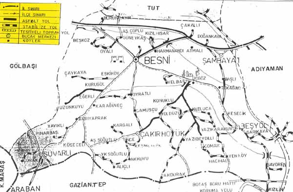
Ancient Mounds: In the south and west of his province are many mounds that were either grave sites or human settlements. The names of these tumulus are Besyol (Sahantil), Cakirhoyuk, Ucgoz (Sofraz), Kutluca (Fal), Yukarihaskisi, Comak, Tasliyazi (Terbizek), Sambayat, Lovzin, and Yayikli (Zirce).
Besni Fortress: The fortress was built in the city of Eski Besni (old Besni) on a very high inaccessible mountain three sides of which are sheer rock. Access was from one side only and thus easily defended. Parts of the wall are still standing and the catapults used can be seen. The castle has also been called Aslanagzi, Guvercin, Goksu, Keklik Goksu and Bozmekan. The fortress was originally built by the Hittites and has inscriptions from Memluk times.
Degirmen Cayi (Sugozu): About 10 km to the south of Besni near the headwaters of the Sofraz Stream is Degirmen Cayi. The scenery is beautiful, green and in contrast are the sharp rocks in which are natural caves where primitive man once lived. These caves are all along the river and are given names by the local people according to what they look like.
Old Besni Remains: The fortress of Besni is located 4-5 km to the south of the more recent site and present city of Besni, The city used to surround the castle. Important remains today are some mosques, a minaret, a bath, a fountain and a bridge.
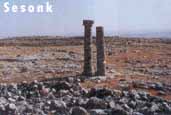 Dikilitas
(SESONK): Dikilitas built on Kizildag in the village of Zormagara,
Besni district. It is 5-6 m. high tumulus which is made of rough stone.
Today, most of the double columns are surrounding Sesonk. A tumulus
lies on Kizildag mountain near Asagihozgisi village 33 kilometers southeast
of Besni. This tumulus, called Dikilitas or Sesonk (three stones) is
thought to date to the Kingdom of Kommagene (69 B.C. 72 A.D.) It is possible
that it contains the burial of a king or member of a royal family. 6 columns
in all surround the 20 meter high tumulus. These, each made of
superimposed drum sections of great size, lie paired to the mound's
northeast, northwest and south. The form of these columns found at the
Karakus tumulus, the Goksu bridge over the Goksu River, and the Cendere bridge
over the Kahta River. Each column consists of 8 drum sections, about 1.5
meters in diameter and one meter high, placed one atone the next. Each
column rises to a height of between 15-20 meters. The view form the top of
the tumulus stretches to a great distance. In addition, another interesting
feature of this site, is a large well sunk 7 to 8 meters straight into the
rock. This well, resembling the entrance to a cave or cistern, was thought
to pertain to the tumulus itself. The easiest method of attaining access
to this site by motoring to the village of Coplu in the district of Yenikoy, and
thereupon by foot.
Dikilitas
(SESONK): Dikilitas built on Kizildag in the village of Zormagara,
Besni district. It is 5-6 m. high tumulus which is made of rough stone.
Today, most of the double columns are surrounding Sesonk. A tumulus
lies on Kizildag mountain near Asagihozgisi village 33 kilometers southeast
of Besni. This tumulus, called Dikilitas or Sesonk (three stones) is
thought to date to the Kingdom of Kommagene (69 B.C. 72 A.D.) It is possible
that it contains the burial of a king or member of a royal family. 6 columns
in all surround the 20 meter high tumulus. These, each made of
superimposed drum sections of great size, lie paired to the mound's
northeast, northwest and south. The form of these columns found at the
Karakus tumulus, the Goksu bridge over the Goksu River, and the Cendere bridge
over the Kahta River. Each column consists of 8 drum sections, about 1.5
meters in diameter and one meter high, placed one atone the next. Each
column rises to a height of between 15-20 meters. The view form the top of
the tumulus stretches to a great distance. In addition, another interesting
feature of this site, is a large well sunk 7 to 8 meters straight into the
rock. This well, resembling the entrance to a cave or cistern, was thought
to pertain to the tumulus itself. The easiest method of attaining access
to this site by motoring to the village of Coplu in the district of Yenikoy, and
thereupon by foot.
Goksu Bridge
(Kizilin Bridge): This bridge is between two villages Gumuskaya and
Again in the
district of Besni. Goksu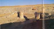 bridge was built by the Romans and it looks like
Cendere Bridge. This bridge from Roman times is on the Goksu River
Kizilin, southeast of Besni. It is more interesting than the Cendere
bridge even though they are similar. The middle section of the bridge is
in ruins but other parts are complete. The bridge has three arches the
middle section having a 20-30 meter span between the two columns. An inscription
on the bridge to how great and magnificent Samsat once was.
bridge was built by the Romans and it looks like
Cendere Bridge. This bridge from Roman times is on the Goksu River
Kizilin, southeast of Besni. It is more interesting than the Cendere
bridge even though they are similar. The middle section of the bridge is
in ruins but other parts are complete. The bridge has three arches the
middle section having a 20-30 meter span between the two columns. An inscription
on the bridge to how great and magnificent Samsat once was.
Goksu Caves: All along the Goksu river Are interesting caves at a height of 40-50 meters some of which are 7-8 stores. Some caves ware used as graves also most of the caves in the Adiyaman side of the river are near Gumuskaya and on the Besni side are near Kizilin, Sarakaya and Malpinari.
Dolmen: These interesting monuments lie on a hill north of Dikilitas (Sesonk) which is near Asagihozgisi Village, and are Neolithic graves of the Dolmen or Monolith type. They are constructed of 2 large square rocks leaning against one another.
Sofraz Ruins of Kul Sehri: The ancient city of Kul Sehri is 15 km to the southeast of Besni located in and around the village of Alisar. This village has important ruins and of historical value are two mosques, Hasan Pasa mosque, Ulu Mosque and a minaret, Oksuz. In the ruins of Kul Sehir bottles filled with chloral earth have been found, the secret of which has not yet been solved.
Besni Icmesi (Cormuk icmesi): The healing waters of Besni icmesi, 6 km northeast of Besni, Contain bicarbonate, magnesium and calcium. Drinking 200 CC three times a day it is greatly effective for the cures of constipation, stomach and intestinal disorders.
![]()
Pictures from Besni and its environment..!
![]()
Home | Ana
Sayfa | All About Turkey | Turkiye
hakkindaki Hersey | Turkish Road Map
| Historical Places in Adiyaman | Historical
Places in Turkey | Mt.Nemrut | Slide
Shows | Related Links | Guest
Book | Disclaimer | Send a Postcard | Travelers' Stories | Donate a little to help | Getting Around Istanbul | Adiyaman Forum
|
|