
Central District (The city of Adıyaman)
ADIYAMAN - ADMINISTRATIVE STRUCTURE AND HISTORICAL SITES
About Adiyaman-General Info (Right Click Here)
Pictures
from Adiyaman (Right Click Here)
 Turkey
is divided into provinces, an administrative system barrowed from France. There
are 81 provinces (il) in Turkey. Each province is then subdivided into smaller
administrative units called ilçe (district), roughly
equivalent to a county in the U.S. Provinces are usually named after the biggest
city in that province. The two other large subdivisions are also named for the
biggest settlements in that division. Adıyaman is not only the largest city
in that province, it is also that province’s “central” district (ilçe).
Each İlçe is
subdivided into Bucak (like a township) and each bucak is further divided into
villages (köy). Adıyaman
has 9 districts (including the central one) and 12 bucaks
(townships).
Turkey
is divided into provinces, an administrative system barrowed from France. There
are 81 provinces (il) in Turkey. Each province is then subdivided into smaller
administrative units called ilçe (district), roughly
equivalent to a county in the U.S. Provinces are usually named after the biggest
city in that province. The two other large subdivisions are also named for the
biggest settlements in that division. Adıyaman is not only the largest city
in that province, it is also that province’s “central” district (ilçe).
Each İlçe is
subdivided into Bucak (like a township) and each bucak is further divided into
villages (köy). Adıyaman
has 9 districts (including the central one) and 12 bucaks
(townships).
Vali
(governor) administers the province, kaymakam the districts (ilçe), and nahiye
müdürü oversees the bucak. The governor (vali) also acts as the
administrative head of the central district. Each major settlement in a
province also elects a mayor, called belediye reisi. The mayors of these settlements deal only with the physical infrastructure of the cities while the
government appointed civil servants are in charge of the
settlements deal only with the physical infrastructure of the cities while the
government appointed civil servants are in charge of the
courts, security and
other central functions like census bureaus, public health, and public education.
 Central
District (The city of Adıyaman): According to 1990 census the population of the
central district of the province was 170,75 including bucaks and villages.
However due to recent migration, mostly caused by the displaced villagers due to
the Atatürk dam (part of Southeastern Anatolian project, called GAP), the population
is estimated to be over 200,000. GAP has accelerated the economic activity of
the city, especially in light industry.
Central
District (The city of Adıyaman): According to 1990 census the population of the
central district of the province was 170,75 including bucaks and villages.
However due to recent migration, mostly caused by the displaced villagers due to
the Atatürk dam (part of Southeastern Anatolian project, called GAP), the population
is estimated to be over 200,000. GAP has accelerated the economic activity of
the city, especially in light industry.
Adıyaman
rapidly developed after becoming a province in 1954. Although it is
now a fairly
modern city, the major activity in the central district still remains to be
farming and animal husbandry.
Atatürk dam, 25 miles from the central city, combined with the deep historical
roots of the region
has made tourism an important activity for the city. Pirin
caves and rock tombs are important historical sites in the central region.
Historical Places around
Adiyaman (Central District):
Oturakci Bazaar: Oturakci Bazaar is a favorite place for all tourists, which is the centre of town in Adiyaman. One can find some original hand-made carpets, kilims and bags there.
Adiyaman Fortress (Hisn-i Mansur): Build on a mound at an altitude of 25 meters in the city center. In the past, the city's first name was Hisn-i Mansur, the city later became known as Adiyaman.
Pirin
Cave-Graves (Rock Tombs): 5 km. from Adiyaman, is the ancient city of
 Perre,
famous for its cave graves (rock tombs) numbering 208. The city whose
history reaches back thousands of years, are found in this area. This
city's place and city walls plus 208 caves carved into the rocks are left until
today. Even today we can see human relief over the doors of the
caves.
Perre,
famous for its cave graves (rock tombs) numbering 208. The city whose
history reaches back thousands of years, are found in this area. This
city's place and city walls plus 208 caves carved into the rocks are left until
today. Even today we can see human relief over the doors of the
caves.
Haydaran Rock Tombs: In the village of Tasgedik, 17 km. north of Adiyaman are the Haydaran Rock Tombs and relief. The Haydaran Caves are in the district of Haydaran . On the door of one of theses caves is a relief of two men facing each other. Their style of dress is especially interesting.
Planli
Cave: This is one of the most interesting of the natural caves on the
way to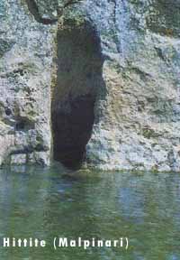 Haydaran north of Adiyaman. On the walls of the cave are very
primitive drawings of goats and dear. Archeologists believe theses are
drawings from the Paleolithic Age. 10 km. north of Adiyaman is a natural cave used by ancient people in Paleolithic
ages.
Haydaran north of Adiyaman. On the walls of the cave are very
primitive drawings of goats and dear. Archeologists believe theses are
drawings from the Paleolithic Age. 10 km. north of Adiyaman is a natural cave used by ancient people in Paleolithic
ages.
Zey Early reign Christians were settled: Zey is a small village 7 km from Adiyaman. Near this village is Kitap cave and a two store fortress, Demir Kale, carved from rock that was once a human settlement. There is also a mosque and the mausoleum of seyh Abdurrahman Ercincani, both built by Murat IV. Early reign Christians were settled near the Zey village.
 Bestepeler
Tumulus (Firlaz Hoyuk): Going 25 km southwest of Adiyaman brings one to the
banks of the Goksu river and the village of Firlaz (Ilicak) where there is a
large mound. Excavation of the mound reveals that it was a human
settlement over several historical periods. Close by to the north of the settlement
are 5 tumuli believed to be grave sites. The local people call it Besevler,
meaning "five houses".
Bestepeler
Tumulus (Firlaz Hoyuk): Going 25 km southwest of Adiyaman brings one to the
banks of the Goksu river and the village of Firlaz (Ilicak) where there is a
large mound. Excavation of the mound reveals that it was a human
settlement over several historical periods. Close by to the north of the settlement
are 5 tumuli believed to be grave sites. The local people call it Besevler,
meaning "five houses".
Malpinari (Hittite): South of Firlak Hoyuk, 35 km from Adiyaman near Goksu is Malpinari where water flows freely from between the rocks. On the face of the rock from which the water flows is a Late Hittite hieroglyphic inscription. Opposite Malpinari, near Besni (on the opposite side of Goksu) are a group of caves carved into the rock 40-50 meters high. From a distance these caves appear to be 5-6 storeys, connected by stairways, doors and windows for light. It is possible to see caves like this all along the Goksu River as far as the Euphrates (Firat) River.


Geography / Adiyaman Museum / Culture / Social / Economy / Health / Education / Tourism / Sport / Transportation / Municipalities / Where does the name come from? / Local Newspapers / Wildflowers / Wildlife
![]()
![]()
Home | Ana
Sayfa | All About Turkey | Turkiye
hakkindaki Hersey | Turkish Road Map
| Historical Places in Adiyaman | Historical
Places in Turkey | Mt.Nemrut | Slide
Shows | Related Links | Guest
Book | Disclaimer | Send a Postcard | Travelers' Stories | Donate a little to help | Getting Around Istanbul | Adiyaman Forum
|
|