
ATATURK
DAM (GAP)

|
|
|
ATATURK
DAM (GAP) |
|
|
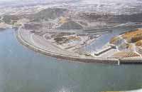 Dam on the Euphrates River in southeastern Turkey, the centerpiece
of the Southeastern
Dam on the Euphrates River in southeastern Turkey, the centerpiece
of the Southeastern Anatolia Project. The Ataturk Dam is the largest in a series
of 22 dams and 19 hydroelectric stations built on the Euphrates and Tigris
rivers in the 1980s and '90s in order to provide irrigation water and
hydroelectricity to arid southeastern Turkey. Completed in 1990, the Ataturk Dam
is one of the world's largest earth-and-rock fill dams, with an embankment 604
feet (184 m) high and 5,971 feet (1,820 m) long. Water impounded by the dam is
fed to power-generating units at Sanliurfa that have a capacity of
2,400 megawatts. From there the water is gravity-fed to vast irrigation networks
in the Harran Plain and elsewhere in the vicinity.
Anatolia Project. The Ataturk Dam is the largest in a series
of 22 dams and 19 hydroelectric stations built on the Euphrates and Tigris
rivers in the 1980s and '90s in order to provide irrigation water and
hydroelectricity to arid southeastern Turkey. Completed in 1990, the Ataturk Dam
is one of the world's largest earth-and-rock fill dams, with an embankment 604
feet (184 m) high and 5,971 feet (1,820 m) long. Water impounded by the dam is
fed to power-generating units at Sanliurfa that have a capacity of
2,400 megawatts. From there the water is gravity-fed to vast irrigation networks
in the Harran Plain and elsewhere in the vicinity.
The Southeastern Anatolia Project (GAP) is a massive $32 billion public project
to harness the power and potential of the upper reaches of the Tigris and
Euphrates rivers and to irrigate the fertile plains that lie between them. When
completed in 2010, 21 dams and 17 hydroelectric power plants will produce
approximately 22% of Turkey's projected electricity requirements, equivalent to
the entire national energy consumption in 1988. The Ataturk Dam, the sixth
largest rock filled dam in the world, is the key structure for the development
of the Lower Euphrates River region. Completed in 1993, it presently generates
8.9 billion kWh in electricity and is responsible for opening more than 180,000
acres of farmland to irrigation in the Harran plain.
electricity requirements, equivalent to
the entire national energy consumption in 1988. The Ataturk Dam, the sixth
largest rock filled dam in the world, is the key structure for the development
of the Lower Euphrates River region. Completed in 1993, it presently generates
8.9 billion kWh in electricity and is responsible for opening more than 180,000
acres of farmland to irrigation in the Harran plain.
The new irrigation systems created by the GAP will double Turkey's irrigable farmland in a region which has traditionally suffered from light rainfall. New irrigation has already brought about a corresponding boom in agricultural activity. From just one crop per year, in many areas five crops in a two-year cycle have become or will soon be possible. Crop yields of cotton, wheat, barley, lentils and other grains have reportedly tripled in the Harran plain as a result of irrigation from the Ataturk Dam. Land values have risen rapidly. Family income, number of personal vehicles and number of tractors in the region have nearly tripled in the past eight years. The range of new products under cultivation is also expanding. Farmers are now experimenting with new varieties of fruits, vegetables, and nuts.
But the Southeastern Anatolia Project encompasses more than dams and tunnels. The purpose of the GAP is to eliminate disparities in the levels of development existing between this region and other regions of Turkey by raising income levels and living standards of the people who live in Southeastern Turkey. The GAP is a fully integrated development project designed to create economic and social opportunities with the full support of the Turkish government.
While dams and irrigation tunnels are being constructed, the Government of Turkey promotes business development through industrial zones in each of the provincial capitals in the GAP region. It is training farmers in the most sustainable and economical land use practices; building airports and highways to ensure sufficient infrastructure for market development; and building schools and other institutions to raise the economic and social standards of the six million people who live in the region. The Government's stated goal is to increase the income level in the region five-fold and generate employment opportunities for 3.5 million people.
 The GAP region consists of eight provinces in Southeastern
Anatolia: Adiyaman, Batman, Diyarbakir, Gaziantep, Siirt, Sanliurfa, Mardin and
Sirnak. Of these, Gaziantep, Sanliurfa and Diyarbakir are now particularly
poised to welcome U.S. direct foreign investment and expanded trade
opportunities. In addition, the nearby provinces of Adana and Mersin, both
outstanding growing areas with access to major population centers and the
Mediterranean Sea, merit strong consideration for U.S. firms contemplating an
investment in the region. Kahramanmaras, like Gaziantep and Sanliurfa, has
exploited new investment in the region to become an industrial power. Finally,
Malatya, a major growing area with solid infrastructure and a dynamic municipal.
government, is ready. to welcome new business activity
The GAP region consists of eight provinces in Southeastern
Anatolia: Adiyaman, Batman, Diyarbakir, Gaziantep, Siirt, Sanliurfa, Mardin and
Sirnak. Of these, Gaziantep, Sanliurfa and Diyarbakir are now particularly
poised to welcome U.S. direct foreign investment and expanded trade
opportunities. In addition, the nearby provinces of Adana and Mersin, both
outstanding growing areas with access to major population centers and the
Mediterranean Sea, merit strong consideration for U.S. firms contemplating an
investment in the region. Kahramanmaras, like Gaziantep and Sanliurfa, has
exploited new investment in the region to become an industrial power. Finally,
Malatya, a major growing area with solid infrastructure and a dynamic municipal.
government, is ready. to welcome new business activity
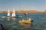
ATATURK DAM INTERNATIONAL SPORTS FESTIVAL
Ataturk Dam Lake is the symbol of an important geographical change which opens up new horizons for the rich cultural heritage of the region. Extending over an area of 817 square kilometers, the dam is called "sea" by local people. The dam has already started to affect people's daily life. "Ataturk Dam Water Sports Festival" which has a history of four years is an important activity expected to enhance the culture of the region in the context of sports.
 The
festival is organized jointly by the Turkish National Committee of Olympics, GAP
Administration, General Directorate of State Hydraulic Works and the General
Directorate of Youth and Sports. The objective of the festival is to promote
tourism, publicize the versatile character of GAP, integrate socio-economic
development with the advent of sports activities and to imbue the young people
of the region with the spirit Olympics. The first of this annual festival was
held on 6-7 October 1995. Then came the second (4-5 October 1996), third (3-4
October 1997), fourth (9-10 October 1998) and the fifth (24-25 September 1999)
festival.
The
festival is organized jointly by the Turkish National Committee of Olympics, GAP
Administration, General Directorate of State Hydraulic Works and the General
Directorate of Youth and Sports. The objective of the festival is to promote
tourism, publicize the versatile character of GAP, integrate socio-economic
development with the advent of sports activities and to imbue the young people
of the region with the spirit Olympics. The first of this annual festival was
held on 6-7 October 1995. Then came the second (4-5 October 1996), third (3-4
October 1997), fourth (9-10 October 1998) and the fifth (24-25 September 1999)
festival.
The last festival was participated by 396 athletes in the branches of sailing, rowing-canoeing, swimming and underwater sports. Among these athletes, there were 22 from Israel and Romania. Also 190 athletes were participated from Sanliurfa and Adiyaman.
The festival will take place each year in October or September.
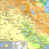 |
| The Tigris and Euphrates river basin and its drainage network. |
 kilometres). The rivers usually
are discussed in three parts: their upper courses, restricted to the valleys and
gorges of eastern Anatolia, at elevations diminishing from those of their
sources at 6,000 to 10,000 feet (1,830 to 3,050 metres) above sea level; their
middle courses, in the uplands of northern Syria and Iraq, at elevations varying
from 1,200 feet at the foot of the so-called Kurdish Escarpment to 170 feet at
the head of the delta; and the alluvial plain, which has been created jointly by
the two rivers. At Al-Qurnah the rivers join to form the Shatt
al-'Arab
kilometres). The rivers usually
are discussed in three parts: their upper courses, restricted to the valleys and
gorges of eastern Anatolia, at elevations diminishing from those of their
sources at 6,000 to 10,000 feet (1,830 to 3,050 metres) above sea level; their
middle courses, in the uplands of northern Syria and Iraq, at elevations varying
from 1,200 feet at the foot of the so-called Kurdish Escarpment to 170 feet at
the head of the delta; and the alluvial plain, which has been created jointly by
the two rivers. At Al-Qurnah the rivers join to form the Shatt
al-'Arab
OVERALL INFORMATION ON GAP
Map of the GAP Region

Click to the map for viewing the larger version of this map
![]()
![]()
Home | All
About Turkey | Turkish Road Map
| Historical Places in Adiyaman | Historical
Places in Turkey | Mt.Nemrut | Slide
Shows | Related Links | Guest
Book | Disclaimer | Send a Postcard | Travelers' Stories | Donate a little to help | Getting Around Istanbul | Adiyaman Forum
Ana Sayfa | Türkiye hakkindaki Hersey | Türkiye Yol Haritasi | Adiyamandaki Tarihi Yerler | Türkiyedeki Tarihi Yerler | Nemrut Tepesi | Dia Gösterisi | Önemli Linkler | Konuk Defteri | Açiklama
|
|